 geocatalogue.geoportail.lu
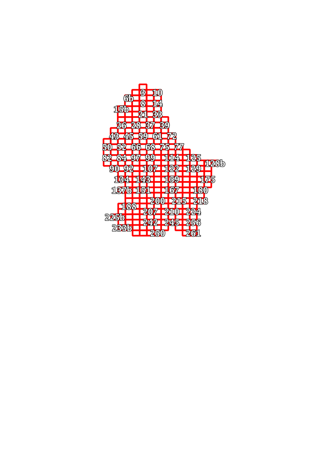
Découpage plan topographique 1:5000 édition 2015
Blatschnëtt topographesche Plang 1:5000 Editioun 2015
Mapsheets topographic plan 1:5000 edition 2015
Blattschnitt topographischer Plan 1:5000 Ausgabe 2015
Simple
-
Date (Publication)Date (Publication)Datumsangaben (Publikation)Date (Publication)
- 2021-02-04
-
IdentificateurCitation identifierIdentifikatorIdentificateur
- / 8c056dc1-bbab-4637-a8e6-1056be3cc4c0
-
EtatStatusBearbeitungsstatusEtat
-
Mise à jour continueOn goingKontinuierliche AktualisierungMise à jour continue
Contact pour la ressource
Point of contact
Kontakt für die Ressource
Contact pour la ressource
No information provided.
-
Fréquence de mise à jourMaintenance and update frequencyÜberarbeitungsintervallFréquence de mise à jour
-
Lorsque nécessaireAs neededBei BedarfLorsque nécessaire
-
Entités au Grand-Duché de Luxembourg
-
-
Grand-Duché du Luxembourg
Grand-Duché du Luxembourg
Grand-Duché du Luxembourg
Grand-Duché du Luxembourg
-
- Keywords
-
-
geoportail.lu
geoportail.lu
geoportail.lu
geoportail.lu
-
-
geoportail.lu themes
-
-
commune
Bestellung
Gemeng
Gemeinde
-
-
geoportail.lu structure
-
-
commune>Commande
commune>Commande>Commande
Gemeng>Commande
Gemeinde>Commande
-
-
Type de représentation spatialeSpatial representation typeRäumliche DarstellungsartType de représentation spatiale
-
VecteurVectorVektorVecteur
-
Langue de la ressourceLanguageSpracheLangue de la ressource
- Français
N
S
E
W
))
-
Nom du système de référenceReference system identifierIdentifikator des ReferenzsystemsNom du système de référence
- EPSG / http://www.opengis.net/def/crs/EPSG/0/2169
- Distribution format
-
Name Version GeoJSON
undefined
- OnLine resource
-
Protocol Linkage Name https://map.geoportail.lu/theme/main?version=3&zoom=8&X=667917&Y=6394482&lang=fr&layers=457&opacities=1 Découpage plan topographique 1:5000 édition 2015
Blatschnëtt topographesche Plang 1:5000 Editioun 2015
Mapsheets topographic plan 1:5000 edition 2015
Blattschnitt topographischer Plan 1:5000 Ausgabe 2015
Metadata
-
Identifiant de la ficheFile identifierMetadatensatzidentifikatorIdentifiant de la fiche
- 01182ea0-3c30-4fc0-9bc2-e2dc778592da XML
-
LangueMetadata languageSpracheLangue
- Français
-
Jeu de caractèresCharacter setZeichensatzJeu de caractères
-
Utf8UTF8Utf8Utf8
-
Type de ressourceHierarchy levelHierarchieebeneType de ressource
-
Jeu de donnéesDatasetDatenbestandJeu de données
- Hierarchy level name
-
dataset
-
Date des métadonnéesDate stampDatumDate des métadonnées
- 2021-02-04T21:52:57
- Metadata standard name
-
ISO 19115:2003/19139:2007
- Metadata standard version
-
1.0
Contact
Metadata author
Metadatenkontakt
Contact
No information provided.
- Other language
-
Language Character encoding LëtzebuergeschLuxembourgish; LetzeburgeschLuxemburgischLuxembourgeoisUtf8UTF8Utf8Utf8EngleschEnglishEnglischAnglaisUtf8UTF8Utf8Utf8DäitschGermanDeutschAllemandUtf8UTF8Utf8Utf8FranséischFrenchFranzösischFrançaisUtf8UTF8Utf8Utf8
)))